2201-2813 English for Tourist Guides
Tourism students at Nakhon Vocational College (Achiwa) began this project of using English and creating a web-site featuring natural waterfalls and caves in Nakhon Si Thammarat, Thailand.
Students have provided photos, and information about the waterfalls.
Contact: Will Anderson
Contact e-mail: [email protected]
* * * *
Students have provided photos, and information about the waterfalls.
Contact: Will Anderson
Contact e-mail: [email protected]
* * * *
Also try: http://wn.com/Waterfall_in_Nakhon_si_thammarat
Last Updated July 2011
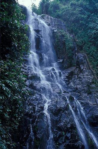
Wang Lung Waterfalls ( น้ำตกวังลุง ) nam tok wang loong
Wang Lung Waterfalls
Wang Lung waterfalls are small and private. You can drive 40 KM to the waterfalls from Nakhon Si Thammarat on Highway 4016 going towards Phrom Lok and turn left at Ban Wang Lung (Highway 4141) there are road signs in English. It is part of the Khao Luang National Park and has a gate but there is no charge to enter at this time. There is a parking lot and a restaurant which is sometimes opened on weekends. There is a hiking trail leading through rubber trees and fruit trees which will take you to higher levels of the falls. There are many private pools and falls.
http://maps.google.com/maps?hl=en&cp=32&gs_id=6f&xhr=t&q=Wang+Lung+Waterfall+Phrom+Khiri+Nakhon+Si+Thammarat+Thailand&qe=bmFraG9uIHNpIHRoYW1tYXJhdCwgdGhhaWxhbmQsIGthcm9tIHdhdGVyZmFsbHM&qesig=GKtwXMSc6GCrJ3joNW5gNA&pkc=AFgZ2tlMaecDjW212KUC6Vg6Ucf34ylxXmDsvdwsQY3236pLx5pdCYKdWI8uM73_5wkqw6dnLaw9k0CIB3fgTsXfqAEow0Dfdw&safe=off&bav=on.2,or.r_gc.r_pw.&biw=1066&bih=530&um=1&ie=UTF-8&hq=&hnear=0x3053a4e6a3812c91:0x117b1cab32d43285,Wang+Lung+Waterfall,+Thon+Hong,+Phrom+Khiri,+Nakhon+Si+Thammarat+80320,+Thailand&ei=aRQgTteKMYPirAeivLX8AQ&sa=X&oi=geocode_result&ct=image&resnum=1&ved=0CBUQ8gEwAA
http://maps.google.com/maps?hl=en&cp=32&gs_id=6f&xhr=t&q=Wang+Lung+Waterfall+Phrom+Khiri+Nakhon+Si+Thammarat+Thailand&qe=bmFraG9uIHNpIHRoYW1tYXJhdCwgdGhhaWxhbmQsIGthcm9tIHdhdGVyZmFsbHM&qesig=GKtwXMSc6GCrJ3joNW5gNA&pkc=AFgZ2tlMaecDjW212KUC6Vg6Ucf34ylxXmDsvdwsQY3236pLx5pdCYKdWI8uM73_5wkqw6dnLaw9k0CIB3fgTsXfqAEow0Dfdw&safe=off&bav=on.2,or.r_gc.r_pw.&biw=1066&bih=530&um=1&ie=UTF-8&hq=&hnear=0x3053a4e6a3812c91:0x117b1cab32d43285,Wang+Lung+Waterfall,+Thon+Hong,+Phrom+Khiri,+Nakhon+Si+Thammarat+80320,+Thailand&ei=aRQgTteKMYPirAeivLX8AQ&sa=X&oi=geocode_result&ct=image&resnum=1&ved=0CBUQ8gEwAA
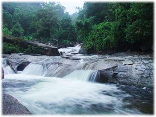
Krung Ching Waterfalls ( น้ำตกกรุงชิง ) nam tok krung ching
Krung Ching Waterfalls
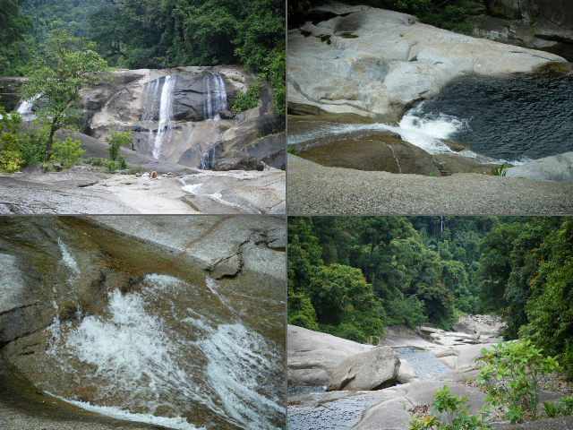
Krung Ching National Park can be found from Nakhon Si Thammarat by driving on Highway 4016 towards Phrom Lok about 70 kilometers. On Highway 4016 you will pass through Na Reng and Nopphitam. It's best to have your own transport to get there, come on an organized trip, or there is a songthaew (a small truck with a covered back and bench seats for passengers) from Nakhon only it stops at the head of the 10km long road down to the national park itself. You could probably find a taxi to get you up there, and get the taxi's phone number. Even a miscall can tell them to come up and fetch you. Just be $kind$, (as always) but patient because it might take them a while to drive back up. It's a beautiful place. The falls themselves are about 3.7km along a mostly-paved trail and there's a sala (a small area with a roof) to sit and rest, or just take in the scenery, every kilometer or so. The falls actually consist of 7 tiers, with some signs on the main path, but just follow the paths. The seventh tier is the big falls known as Fon Saen Hah. This has a viewing platform, and a natural pool which you can soak or swim in. Bring some food and water as there's nothing much to buy on site.
http://www.everythinginnakhon.info/locations/noppitam-krung-ching-waterfall.php
Students: Krainarong Bunsopat, Sila Jamsil, Saranya Talungjit
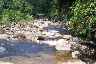
Suan Khan Waterfalls ( น้ำตกสวนขัน ) nam tok sue-ahn kahn

Suan Khan Waterfalls
Suan Khan is in Moo 3, Tambon Suan Khan. It can be reached by taking Highway No. 4015 from Nakhon towards Lan Saka for 55 kilometres and connecting to the Chandi-Phipun bus for another 4 kilometres. The area is very beautiful and is great for trekking and exploring the flora of the area. Three levels of the waterfall can be accessed.
http://maatour-thailand.blogspot.com/2008/01/nakornsithammarat.html
Students: Malinee Wannarangsi, Titaya Sittirak, Sirintip Pukdeerat
http://maatour-thailand.blogspot.com/2008/01/nakornsithammarat.html
Students: Malinee Wannarangsi, Titaya Sittirak, Sirintip Pukdeerat
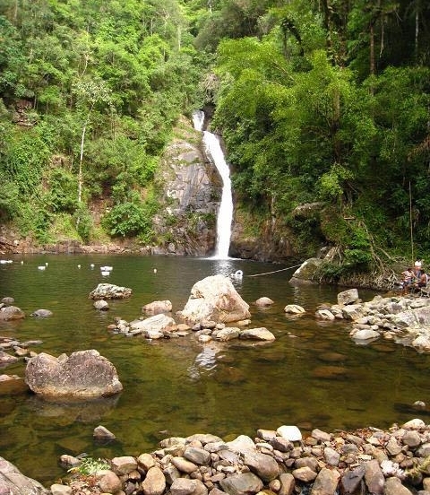
Phrom Lok Waterfalls ( น้ำตกพรหมโลก ) nam tok prom loke
Phrom Lok Waterfalls
Khlong Ta Leak Waterfalls ( น้ำตกคลองท่าหลีก ) nam tok klong tah leek
Khlong Ta Leak Waterfalls
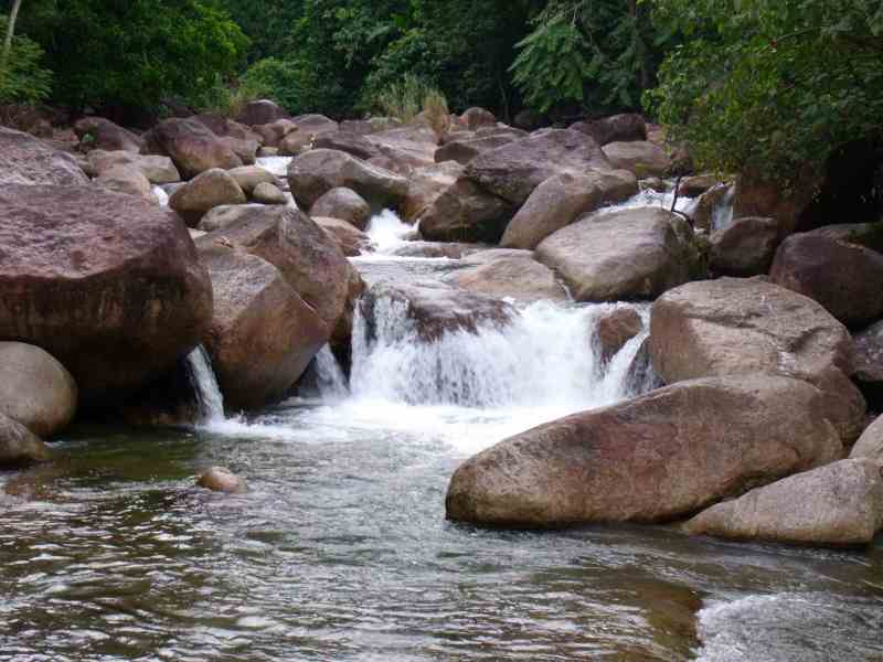
Khlong-Ta-Leak Waterfall consists of seven levels, each of which has different name, for example: Hnanaret, Hnan chang tok, and Hnan toui. The waterfall has a deep pond and a stream which has beautiful rocks and boulders. It is about 28 Kilometers from Nakhon Si Thammarat.
Su Nan Tha Waterfalls ( น้ำตกสุนันทา ) nam tok sue-nan-tha
Su Nan Tha waterfalls
The parks main attraction is the small but lovely Su Nan Tha Waterfall. Water drops down a steep cliff to the pool below before flowing into Khlong Klai, the main waterway of Tha Sala. Rafting can be done in the canal during the rainy season, when the water level is high.
http://thailand.sawadee.com/nakhonsithammarat/attractions2.htm
Karom Waterfalls ( พลอย ) nam tok car-ohm

Karome waterfalls
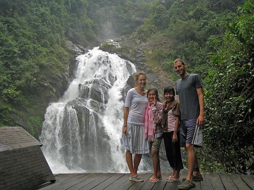
This beautiful natural tourist attraction is in Khao Luang National Park near Lansaka. Karom waterfall is 9 kilometres from the city. Take Highway No. 4016, then turn left onto Highway No. 4015 for 20 kilometres, and the entrance to the waterfall will be on the right. The waterfall originated in the Nakhon Si Thammarat mountain range and cascades down 19 levels, with names like Nan Phung, Nan Nam Ruang, Nan Dat Fa, and Nan Soi Dao (the highest level at 1,300-1,400 metres). For rest and relaxation, just go up 7 tiers. The 7th tier is the most beautiful. It’s called Nan Dadfah. You can see water falling from high cliff with 45 degrees angle along wide rocks to a large pool below that you can swim in. Usually the water will be split into 2 streams. During the rainy season, (October-February) the water will run the whole width of the cliff which is very breathtaking.Kings and royal family members have visited this waterfall, as evidenced by the initials of King Rama V and King Rama VI carved there.
http://www.flixya.com/post/zaa033/1270681/Karom_Waterfall
http://www.tourismthailand.org/where-to-go/cities-guide/attractions/info-page/destination/nakhon-si-thammarat/cat/38/attraction/5389/parent/1105/lang/0/
Students: Patcharin Chouypoon, Pinkamon Suwannasang, Pakarat Jannoon
Ai Keow Waterfalls ( น้ำตกอ้ายเขียว ) nam tok eye key-ow
Ai Khiao or Nai Khiao Waterfall
Ai Khiao or Nai Khiao Waterfall, is in Tambon Thon Hong. It is 30 kilometres from Nakhon Si Thammarat on Highway No. 4016, on the same route as Phrom Lok waterfall. At the 26-km marker, turn left onto the road and continue for another 3 kilometres. Originating from Khao Luang mountain, this waterfall has 9 levels, which are Nan Chong Sai, Nan Bang Bai, Nan Mai Phai, Nan Sua Phan, Nan Buppha Sawan, Nan Hin Kong, Nan Hua Chang, Nan Sai Kwat Lan, and Nan Fa Faet. The surrounding area is still a dense jungle. Both sides of the falls are covered with betel nut gardens. The locals call the betel nut Phlu Pak Sai because of its hot flavor and sweet scent. There is a great view of Khao Luang mountain from here.
http://thailand.sawadee.com/nakhonsithammarat/attractions2.htm
http://thailand.sawadee.com/nakhonsithammarat/attractions2.htm
Hnan Hin Tha Ha (หนานหินท่าหา) nam tok naan hen tha hah
Hnan Hin Tha Ha waterfalls
Hnan Hin Tha Ha is a huge multi-cascade waterfall in the southern part of the Khao Luang National Park To drive there take the Nakhon Si Thammarat Lansaka Road for 34 kilometres.
Yong ( น้ำตกโยง ) nam tok yong
Yong or Yong Sai Yai waterfalls
Namtok Yong National Park, or locally known as Yong Sai Yai waterfall, was proclaimed a national park on December 10, 1987. The parks pristine nature includes the Yong Waterfall where streams converge into one giant rope-like waterfall dropping from a high cliff to the large pool below. To get to the park, take the Nakhon Si Thammarat-Thung Song Road for 50 kilometres, turn right, and drive for 3 kilometres to the park.
http://thailand.sawadee.com/nakhonsithammarat/attractions2.htm
Si Kheed ( น้ำตกสี่ขีด ) nam tok see khiit
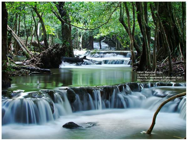
Si Kheed Waterfalls
Si Kheed (Si Khit) waterfalls are located in the Si Kheed National Park located in Par Yang Prong National Forest Reserve and Khao Yai National Forest Reserve, Si kheed Sub-district, Sichol District, Nahkon Si Thamarat province. This area, about 60,625 Rais (97 squares kilometers), and was declared a national park since June 17, 1999.
http://www.thailandtraveltours.com/namtok-si-khit-national-park.htm
Students: Floleda Ratchapakdee, Phuwadon Aurikun, Sayanee Suksheen
Khao Luang Mountain (National Park)
( อุทยานแห่งชาติเขาหลวง ) cow loo-ahng
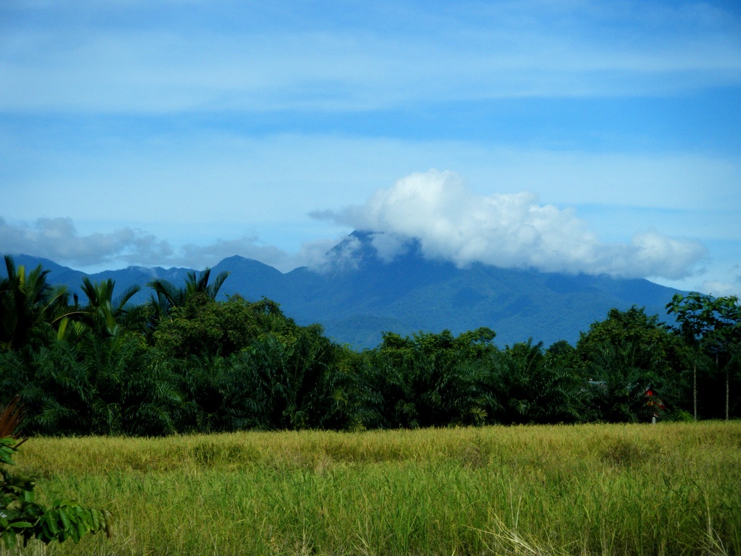
Khao Luang mountain
Khao Luang peak is the tallest mountain in the park. About 1,835 meters (6020 feet) tall, it is accessible from Khiriwong village. You can walk up to the summit and back on a 3 day (2 nights) trek. It is an enjoyable trip, (although difficult and steep at times) particularly for those with an interest in studying forests and vegetation. Khiriwong village is 26KM from Nakhon Sri Thammarat. Follow Highway 4015 for 20KM before you reach Lan Saka take a right turn off the main road, which will take you a further 6KM to the village.
http://www.dnp.go.th/parkreserve/asp/style1/default.asp?npid=198&lg=2
http://www.dnp.go.th/parkreserve/asp/style1/default.asp?npid=198&lg=2
